Spring Equinox ’21 – The Road Trip

Last Thursday we decided to rent a car and go on a day trip in order to celebrate my incoming birthday and spring equinox. We might actually turn it into a quarterly road trip tradition.

Equipped with snacks, we leave the city early morning and head north-east towards Ringsjön lake. The morning sun looks promising, but grey clouds quickly take over the sky. We reach our first stop after a brief drive.

Trollakistan

Trollakistan stands by the road leading to Höör, just before it goes in between eastern and western part of the lake Ringsjön. We have passed this place many times on a motorcycle, so I’m surprised to see that the trees growing from the mound are gone. Only stumps (and litter) remain. Now I can see how the monument functions in the landscape, and imagine how it could look when it was first erected some 5,300 years ago.

Dolmen comes from the Farmers Stone Age period. No grave deposits were found during the excavation of the chamber. However, many flint tools, weapons, and pottery shards were excavated nearby. Fog starts to roll in as I circle the mound to find the best angles; not an easy task to do since the monument stands near the main road where the morning traffic is quite busy.
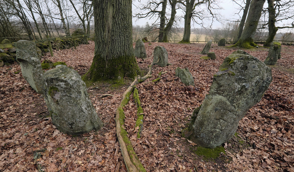
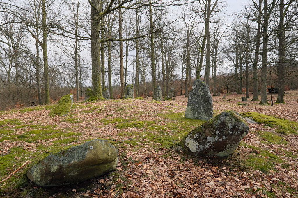
Nunnäs Gravfält

We leave the main road and head for the Nunnäs grave field that lays on the eastern side of Ringsjön. The rural road leads us among the foggy fields and pastures. Nunnäs site is located just behind a farm in Fulltofta. Unlike many other burial sites I’ve seen this looks like an old cemetery park – with its ancient trees and a stone fence. The place, also known as Grykull, comes from the Viking Iron Age and consists six stone ships, two judge rings, 35 raised solitary stones, and clumps of boulders. Originally it was much bigger; many of the stones are missing.

Vätteryds Gravfält

We’re soon back on the trail, and as we continue towards Sösdala we come across another burial site, Vätteryds, which is the biggest and best preserved Iron Age grave field in Skåne. There are around 375 stones on the pasture, but the records from 19th century mention that there were nearly 600 of them left back then.

There are 15 (!) stone ships of various design, a judge ring, two rectangular stone graves and many scattered solitary stones that perhaps once were a part of a bigger structures. The tallest boulder is over 2 meters high. Each stone setting contained a cremation burial of several generations of people. Stone ships were most likely intended for Viking chiefs and warriors. Neolithic settlement was also discovered nearby during the excavations.

According to the local folklore one of the stones was a home to a giant named Klack. Klack had a nasty habit of kidnapping the local girls. When the villagers grew tired of his doings, they attempted to fight him. The stones scattered on the field are supposed to be a memorial of this long and tough battle.

Häglinge Gravfält

Häglinge grave field is in close proximity to Vätteryds site. It’s also a stone throw from Källundagård; the farm that supplies my bakery with rye. This is the third Viking Age burial place we’re visiting today, but no less impressive.

The stones are located on a hill, so they’re not directly visible from the road. There are two stone ships and nearly 70 standing stones on the site. However, it’s hard to imagine how the grave field once looked, since most of the stones are destroyed. What I really like about this place is the green glow and calming omnipresence of moss.

The incredibly tall boulder at the back draws my attention; perhaps once it was of great importance. I think I can see a hidden face on it, but it just might be my imagination.

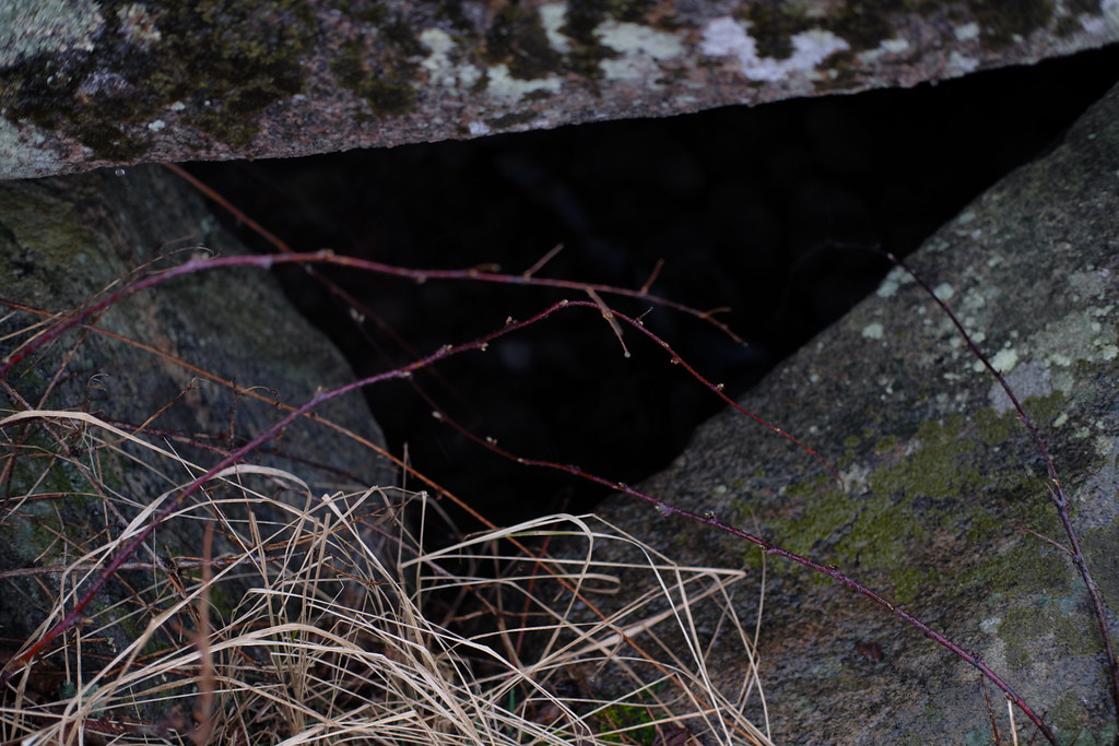
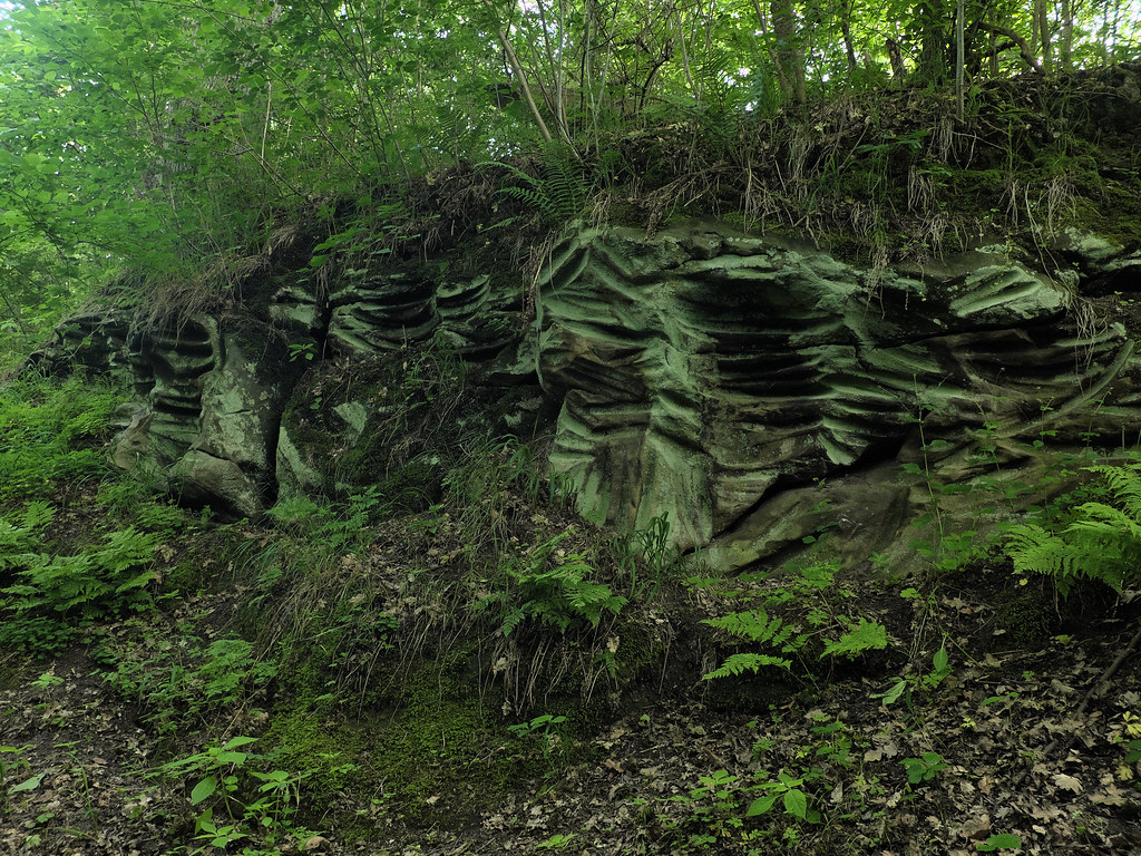
Petroglyphs in Frännarp

We finally arrive here early afternoon. We eat lunch in the sun while listening to a weird bird symphony – woodpecker’s ferocious pecking and continuous croaks of a raven family circling high above our heads. The site really makes a great bird observation spot. Carvings are located a bit deeper in the thicket, overlooking a small lake.

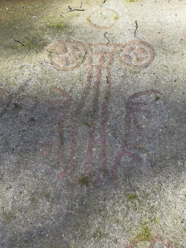
Frännarp’s petroglyphs were discovered in 1906 by one clumsy cow that slipped on the rock slab and tore away the moss covering the carvings.

No other place in Sweden has such a diversity of wagon carvings; it’s also Skåne’s only petroglyph site that isn’t located near the coast. There are around 17 two-wheeled carriages, some of them are pulled by horses. In addition there are sun wheels, snakes, a ship (or not; my sources are contradictory), 61 cup marks, miniature foot soles and a few unidentified figures.

Symbols were most likely carved during the Bronze Age. Back then pastures and cultivated fields dominated the surrounding landscape. The presence of wagons and sun wheels not only correspond to the daily farming struggle and dependence on cycles of nature, but can also be connected to fertility rituals performed to secure a good harvest.

Sources:

  1. Enoksen Lars Magnar, Skånska fornminnen, Historiska Media, Lund 2001.
  2. Classon Christer, Dunér Anders, Fornminnen i Skåne, Corona Förlag, Malmö 2001.

Megalithic Walk around Gantofta

It’s been a year since my trip to Gantofta and I think the time has come to write about it. All those months I’ve kept saving it for later, hoping the memories would age like a fine wine, but instead they’ve started to wither. It’s really hard now to excavate the whole experience intact from the depths of my mind. I mostly remember the rain and my feet getting wet but also the exhilarating freedom and joy I felt after each of my tiny discoveries.

One rainy Monday in March I’ve decided to hop on a train and ramble around the Råån’s valley. My hike started at Gantofta’s station since the village is directly accessible by train from Malmö. The weather was fine by the time of my arrival but, as soon as I’ve headed for Bårslöv, it started to rain again. Undiscouraged by moisture I crossed the river and continued towards Stenlösorna Dolmen.

Stenlösorna is hidden on a neglected meadow behind private premises on the left of the road to Bårslöv. It’s overgrown with bushes and guarded by a hawthorn tree. Hawthorns symbolism in folklore is somewhat similar to an elder; it too stands at the threshold of the Otherworld. The dolmen’s capstone is covered in lichens and moss, though still some cup marks should be visible. As per usual I haven’t noticed any.

After a brief investigation I’ve turned back towards Gantofta and followed the road leading to Fjärestad. It was a 3-4 km walk along a less busy road during the worst rain; then a quick stroll through the Fjärestad Gård where the time has stopped. After a while I’ve found myself on a gravel road that led through the sleeping fields. An overgrown Bronze Age burial mound can be seen from there; looking like a crown in the middle of a field.

The rain stopped immediately after I’ve reached Fastmårupsdösen. The universe smiled at me – I could easily snap some photos. Similarly to Stenlösorna, I’ve learned nothing about it since the place hasn’t been excavated nor any on-site information is provided. I can only rely upon the dry field notes I’ve found on raa.se. In this case the capstone is also adorned with cup marks.

I’ve taken off my raincoat and had a small fika to recover my energy. I’ve had to decide whether I want to go back to Gantofta by the exact same way I came, or take a risk and go down the valley and cross the railway. Since I knew that the dolmen is aligned with Gantoftas Sliprännor I went with the latter.

So I went down the soggy meadow towards the railway. The railway itself wasn’t a problem to cross as I’ve thought before. Though a 3 meter wide river was. Surprise, surprise! There wasn’t any bridge I could take so I’ve decided to find one and walked down the stream.

As I was walking along the river I’ve crossed the Nature Reserve’s territory a couple of times. The hike would be so much easier and shorter if I wouldn’t have to crawl under the electric fences here and there. Though it definitely was fun. At this point my boots were totally soaked and I’ve started to get hungry.

In prehistoric times the region held an important central function and had been an attractive communication hub because of it’s incredibly fertile soils and close proximity to the sea. It’s quite clear from the number of visible ancient remains mainly in the form of a megalithic graves, Bronze Age and Iron Age burial mounds, settlements and fort ruins.

Closer to Gantofta, almost at the end of the nature reserve area, I’ve stumbled upon a mound with two old oak trees (found a noose hanging from one) with an unnamed passage grave in the middle. Unfortunately it hasn’t been restored yet, though it has been excavated in 1902. Back then archeologists found a few scattered deposits of grave goods: amber beads, flint tools and daggers, charred human bones, horse teeth, whetstones and ornamented pottery shards.

Just after I’ve made my final discovery, a wooden bridge appeared out of thin air. I’ve completed the quest. I could finally cross Råån safely and head back to the village.

I had a satisfying fika at Cafe Dalstugan. After talking to the lovely owner I’ve decided to walk through Gantofta to see Gantoftadösen again.

The dolmen can be found just at the end of the village. It’s also known as Jättestugan (Giant’s House). It was restored as the capstone has been broken in two. It features some cup marks as well, very visible this time.

I’ve visited Gantoftadösen already during the summer of 2017. The hike doesn’t have to end there, though last year it did for me. I headed to catch my train home. However, said summer, after continuing down the road for 15-20 mins I’ve reached the last stop on the map – Gantoftas Sliprännor.

The mysterious Giant’s Grooves are hidden in a tiny ravine under a lush foliage. This place is unreal. Like an enchanted emerald chamber; radiating green and moisture. There is a brook at the bottom too. One of the sandstone slopes is covered in peculiar grooves and cup marks.

It is unknown how, when or why the cuts have been created. They were once thought to be made by neolithic folk sharpening their flint knives and axes. Modern research shows that they were probably caused by a rotating motion instead, perhaps using a wheel or pendulum. Today it is believed that those cuts are the remains of magical and religious rituals.

Historical maps of the village of Gantofta show that during the Middle Ages there was an increased interest in owning a narrow plot of land right there, but the reasons behind it remain unknown.

Grooves are common in northwestern Skåne, especially in Kullaberga, but they can also be found on Gotland where they appear mostly on single boulders. In folk belief some of them are called sword sharpening stones.