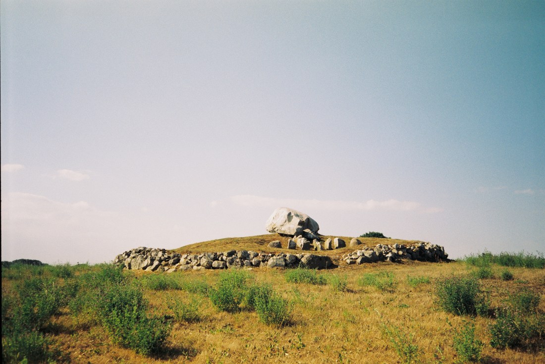
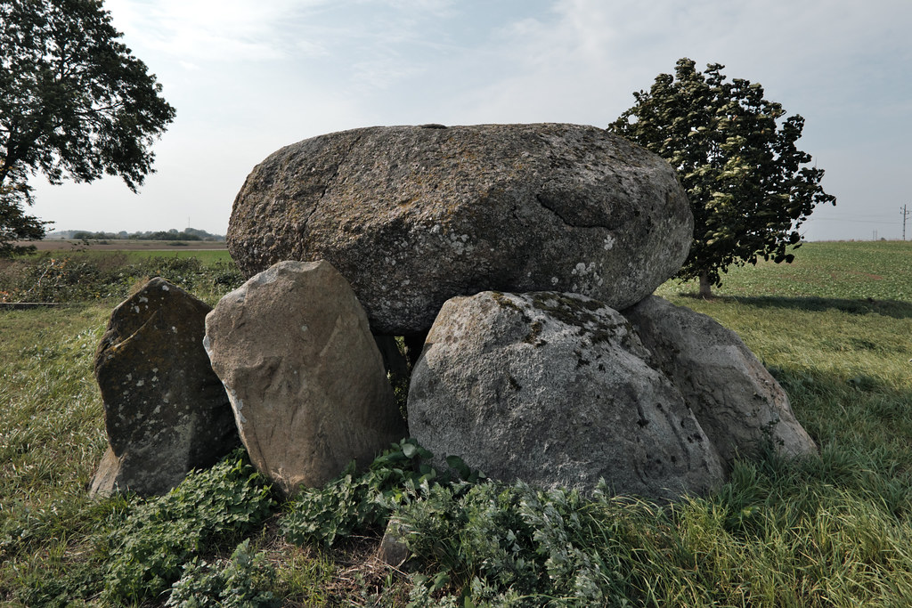
The area between Gladsax and Baskemölla is a distinct ancient landscape that is abundant in burial sites from different eras. One of them is located on a hill behind Rosdala Farm. The very much unique Stenstuan – a passage grave from the Stone Age.
Stenstuan was erected during the Farmer’s Stone Age and was used as a tomb for many generations. What makes it so unique is a variety of petroglyphs carved on its capstone. However, most of the carvings were added during the Bronze Age. Some researchers believe that a part of the 90 cup-marks at the top of the block, may have been carved when the tomb was built. In that case, there is a difference of a couple of thousand years between the first and last carving. The motives are quite few, but the variation is great. There are ships, axes, sun wheels and a circle. One ship carries a sun figure while another – a bowmen. The circle has been interpreted as a bracelet.
The grave was excavated in 1978 by Göran Burenhult. Many exciting discoveries were made, mostly from the Stone Age. Around 4000 ceramic fragments were found at the entrance to the chamber. Other finds included amber beads, burnt mussel’s shells, chisels and broken flint axes.
Photos taken with Olympus Mju I with a Fujicolor 100 negative.
It’s been a year since my trip to Gantofta and I think the time has come to write about it. All those months I’ve kept saving it for later, hoping the memories would age like a fine wine, but instead they’ve started to wither. It’s really hard now to excavate the whole experience intact from the depths of my mind. I mostly remember the rain and my feet getting wet but also the exhilarating freedom and joy I felt after each of my tiny discoveries.
One rainy Monday in March I’ve decided to hop on a train and ramble around the Råån’s valley. My hike started at Gantofta’s station since the village is directly accessible by train from Malmö. The weather was fine by the time of my arrival but, as soon as I’ve headed for Bårslöv, it started to rain again. Undiscouraged by moisture I crossed the river and continued towards Stenlösorna Dolmen.
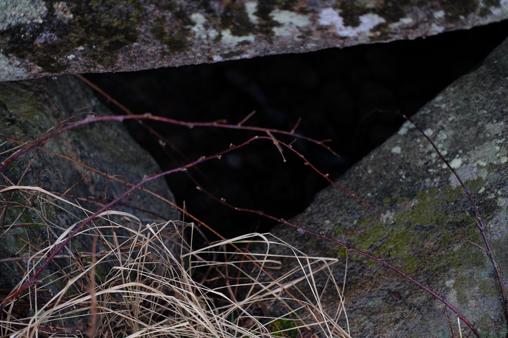
Stenlösorna is hidden on a neglected meadow behind private premises on the left of the road to Bårslöv. It’s overgrown with bushes and guarded by a hawthorn tree. Hawthorns symbolism in folklore is somewhat similar to an elder; it too stands at the threshold of the Otherworld. The dolmen’s capstone is covered in lichens and moss, though still some cup marks should be visible. As per usual I haven’t noticed any.
After a brief investigation I’ve turned back towards Gantofta and followed the road leading to Fjärestad. It was a 3-4 km walk along a less busy road during the worst rain; then a quick stroll through the Fjärestad Gård where the time has stopped. After a while I’ve found myself on a gravel road that led through the sleeping fields. An overgrown Bronze Age burial mound can be seen from there; looking like a crown in the middle of a field.
The rain stopped immediately after I’ve reached Fastmårupsdösen. The universe smiled at me – I could easily snap some photos. Similarly to Stenlösorna, I’ve learned nothing about it since the place hasn’t been excavated nor any on-site information is provided. I can only rely upon the dry field notes I’ve found on raa.se. In this case the capstone is also adorned with cup marks.
I’ve taken off my raincoat and had a small fika to recover my energy. I’ve had to decide whether I want to go back to Gantofta by the exact same way I came, or take a risk and go down the valley and cross the railway. Since I knew that the dolmen is aligned with Gantoftas Sliprännor I went with the latter.
So I went down the soggy meadow towards the railway. The railway itself wasn’t a problem to cross as I’ve thought before. Though a 3 meter wide river was. Surprise, surprise! There wasn’t any bridge I could take so I’ve decided to find one and walked down the stream.
As I was walking along the river I’ve crossed the Nature Reserve’s territory a couple of times. The hike would be so much easier and shorter if I wouldn’t have to crawl under the electric fences here and there. Though it definitely was fun. At this point my boots were totally soaked and I’ve started to get hungry.
In prehistoric times the region held an important central function and had been an attractive communication hub because of it’s incredibly fertile soils and close proximity to the sea. It’s quite clear from the number of visible ancient remains mainly in the form of a megalithic graves, Bronze Age and Iron Age burial mounds, settlements and fort ruins.
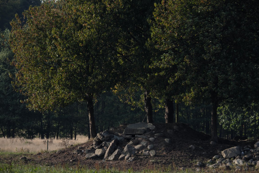
Closer to Gantofta, almost at the end of the nature reserve area, I’ve stumbled upon a mound with two old oak trees (found a noose hanging from one) with an unnamed passage grave in the middle. Unfortunately it hasn’t been restored yet, though it has been excavated in 1902. Back then archeologists found a few scattered deposits of grave goods: amber beads, flint tools and daggers, charred human bones, horse teeth, whetstones and ornamented pottery shards.
Just after I’ve made my final discovery, a wooden bridge appeared out of thin air. I’ve completed the quest. I could finally cross Råån safely and head back to the village.
I had a satisfying fika at Cafe Dalstugan. After talking to the lovely owner I’ve decided to walk through Gantofta to see Gantoftadösen again.
The dolmen can be found just at the end of the village. It’s also known as Jättestugan (Giant’s House). It was restored as the capstone has been broken in two. It features some cup marks as well, very visible this time.
I’ve visited Gantoftadösen already during the summer of 2017. The hike doesn’t have to end there, though last year it did for me. I headed to catch my train home. However, said summer, after continuing down the road for 15-20 mins I’ve reached the last stop on the map – Gantoftas Sliprännor.
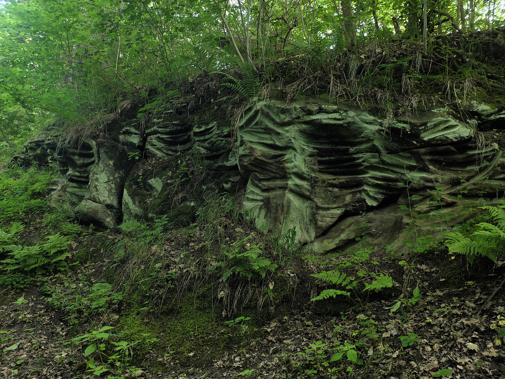
The mysterious Giant’s Grooves are hidden in a tiny ravine under a lush foliage. This place is unreal. Like an enchanted emerald chamber; radiating green and moisture. There is a brook at the bottom too. One of the sandstone slopes is covered in peculiar grooves and cup marks.
It is unknown how, when or why the cuts have been created. They were once thought to be made by neolithic folk sharpening their flint knives and axes. Modern research shows that they were probably caused by a rotating motion instead, perhaps using a wheel or pendulum. Today it is believed that those cuts are the remains of magical and religious rituals.
Historical maps of the village of Gantofta show that during the Middle Ages there was an increased interest in owning a narrow plot of land right there, but the reasons behind it remain unknown.
Grooves are common in northwestern Skåne, especially in Kullaberga, but they can also be found on Gotland where they appear mostly on single boulders. In folk belief some of them are called sword sharpening stones.
A week after my day trip to Smygehuk my parents-in-law drove down and took us for a road trip around Österlen. It’s one of my favorite memories from last year.
We drove along the road number 9. It’s a smaller coastal road perfect for cruising and enjoying the view of the Baltic Sea. We had a fika in Smygehuk’s harbour and later continued along the road through Ystad to Simrishamn, where eventually we had a late lunch. The weather was quite enjoyable; the autumn sun hanged low, trees and grass already started to yellow.
A part of a humongous fairy ring I’ve spotted from the car.
The best part of the trip was a visit to Kiviks Musteri on the east coast. Since it was the apple season, they set up a small harvest festival: pick your own apples, have a fika and taste the local raw products. Before we enjoyed another cup of coffee and buns in the orchard, I’ve stocked up on apples and äpplemust.
While Kivik’s and Simrishamn’s areas are already quite familiar to me, we’ve checked out some previously unknown stone settings along the village roads.
Jarladösen
Jarladösen (Earl’s Dolmen) can be found behind a farm in Järrestad, close to where roads 9 and 11 join together. The village is famous for its well preserved petroglyph site Dansarens häll, which is located a bit towards Gladsax. We’ve already been there couple of years ago. But not many know about two dolmens hidden behind the buildings – Jarladösen, also known as Kycklinghönan since it resembles a hen, and Jarlafruns dös.
Skärabäcksdösen
Vik’s area is known mostly for close proximity of Stenshuvud National Park. But it’s also recognized for apple farming; orchards look truly beautiful this time of the year. Trees bend under the weight of apples as they ripen in the last rays of sunshine. At the end of the village we found Skärabäcksdösen – it was on my list for a while now, but as we took our time and went where the roads took us, we stumbled upon that one by surprise.
Vitabyhus
On the way back home, cruising through the farms and meadows, I’ve spotted some peculiar structures on the pasture past Vitaby. They turned out to be Bronze Age burial mounds. They are quite eroded now due to extensive farming. Originally it was four of them on the field, but I’ve spotted only two.
Älgafallet – amazing waterfall on a border with Norway
Nässjö – thebutthole of Småland? I take it back now!
This road trip took us roughly 4 days. I’ve actually planned a lot (too much?) for us to see on our honey-moon-midsummer-road-trip. Some places didn’t work out – mostly waterfalls and some stone circles. Some other were a surprise as we’ve discovered them by accident. Extremely hot and sunny weather was perfect for a trip, though a bit tiring I’d say, but not so perfect for shooting. Everything went better than expected, we had a lot of fun and I’ve brought plenty of photos home. The greatest trip ever!