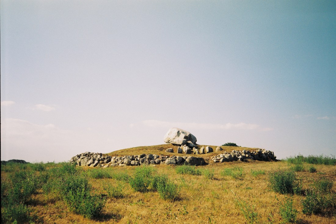
The area between Gladsax and Baskemölla is a distinct ancient landscape that is abundant in burial sites from different eras. One of them is located on a hill behind Rosdala Farm. The very much unique Stenstuan – a passage grave from the Stone Age.
Stenstuan was erected during the Farmer’s Stone Age and was used as a tomb for many generations. What makes it so unique is a variety of petroglyphs carved on its capstone. However, most of the carvings were added during the Bronze Age. Some researchers believe that a part of the 90 cup-marks at the top of the block, may have been carved when the tomb was built. In that case, there is a difference of a couple of thousand years between the first and last carving. The motives are quite few, but the variation is great. There are ships, axes, sun wheels and a circle. One ship carries a sun figure while another – a bowmen. The circle has been interpreted as a bracelet.
The grave was excavated in 1978 by Göran Burenhult. Many exciting discoveries were made, mostly from the Stone Age. Around 4000 ceramic fragments were found at the entrance to the chamber. Other finds included amber beads, burnt mussel’s shells, chisels and broken flint axes.
Photos taken with Olympus Mju I with a Fujicolor 100 negative.
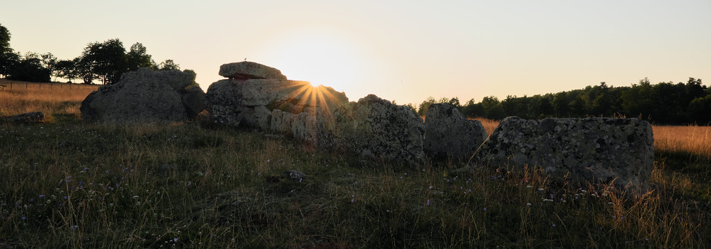
As soon as we installed ourselves in Skövde, we drove up here after a day long drive down from Bollnäs. Just in time for the sunset. Last warm rays of sunlight made the grass turn copper; swarms of flies became fairy dust. As I was walking around the meadow a pair of birds kept me company and followed me wherever I went. Even though I couldn’t identify them, I was grateful for their company for the evening, as it sometimes gets lonely among the graves. Soon after we left to catch Amundstorp in the last moments of the golden hour.
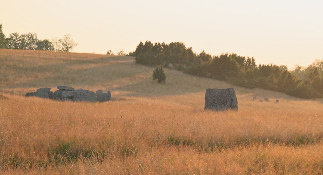
Ekornavallen is an ancient burial ground in the Falköping Municipality in Sweden. Situated in Slafsan River valley, it contains a variety of ancient monuments dating from the Stone, Bronze and Iron Ages.
What’s unusual, there were no settlements in the area until the 18th century. As of the late 19th century the area was plowed up, which sadly destroyed many of the precious remains.
Today Ekornavallen contains four passage graves and a gallery grave from the Neolithic period, as well as cairns from the Bronze Age, stone circles, twelve standing stones (bautastenar) – marking the Iron Age burials, eight round stone settings and one triangular stone setting. Many stones are adorned with cup marks too. It is estimated that the field was in use for over a six to seven thousand-year period.
The largest, and best known, grave on a meadow is the Neolithic passage grave Girommen. According to historians the name translates to thegiant woman’s oven. It could be a resting place of many individuals, possibly an entire family. The burial chamber is thirteen meters long and two meters wide. It stands on a barely recognizable stone setting that is 37 meters in diameter. All boulders are made of sandstone except for the granite roof stone; probably a glacial erratic from Närke. The grave was restored in the 1940s and some burial offerings such as amber beads, pottery shards and a flint chisel have been found. In recent years the walls has been filled to prevent the passage grave from further collapse.
It’s been a year since my trip to Gantofta and I think the time has come to write about it. All those months I’ve kept saving it for later, hoping the memories would age like a fine wine, but instead they’ve started to wither. It’s really hard now to excavate the whole experience intact from the depths of my mind. I mostly remember the rain and my feet getting wet but also the exhilarating freedom and joy I felt after each of my tiny discoveries.
One rainy Monday in March I’ve decided to hop on a train and ramble around the Råån’s valley. My hike started at Gantofta’s station since the village is directly accessible by train from Malmö. The weather was fine by the time of my arrival but, as soon as I’ve headed for Bårslöv, it started to rain again. Undiscouraged by moisture I crossed the river and continued towards Stenlösorna Dolmen.
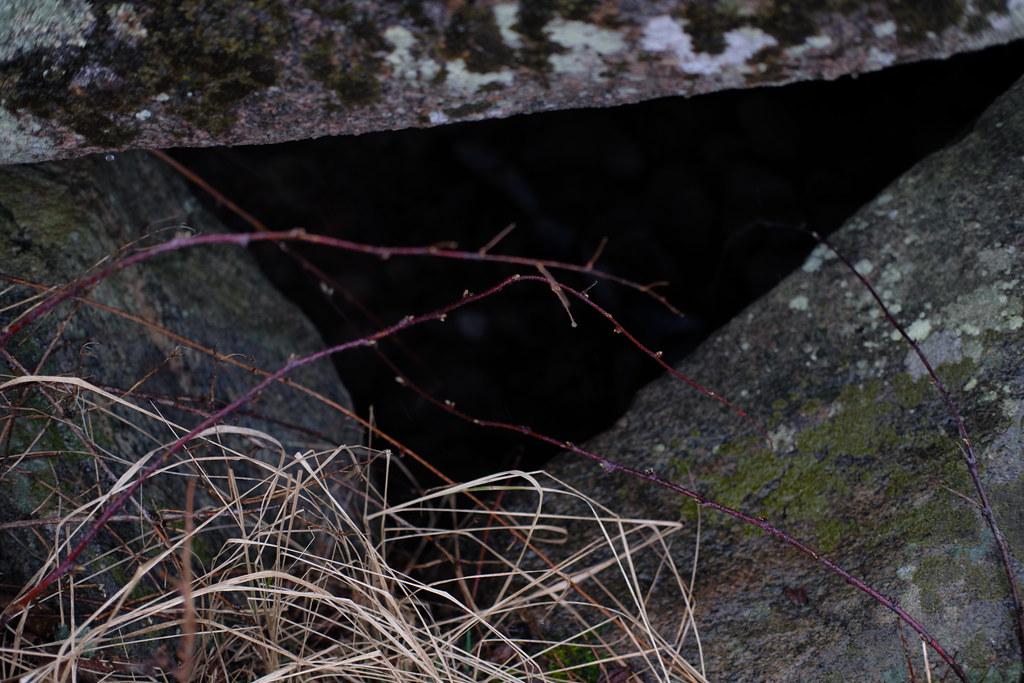
Stenlösorna is hidden on a neglected meadow behind private premises on the left of the road to Bårslöv. It’s overgrown with bushes and guarded by a hawthorn tree. Hawthorns symbolism in folklore is somewhat similar to an elder; it too stands at the threshold of the Otherworld. The dolmen’s capstone is covered in lichens and moss, though still some cup marks should be visible. As per usual I haven’t noticed any.
After a brief investigation I’ve turned back towards Gantofta and followed the road leading to Fjärestad. It was a 3-4 km walk along a less busy road during the worst rain; then a quick stroll through the Fjärestad Gård where the time has stopped. After a while I’ve found myself on a gravel road that led through the sleeping fields. An overgrown Bronze Age burial mound can be seen from there; looking like a crown in the middle of a field.
The rain stopped immediately after I’ve reached Fastmårupsdösen. The universe smiled at me – I could easily snap some photos. Similarly to Stenlösorna, I’ve learned nothing about it since the place hasn’t been excavated nor any on-site information is provided. I can only rely upon the dry field notes I’ve found on raa.se. In this case the capstone is also adorned with cup marks.
I’ve taken off my raincoat and had a small fika to recover my energy. I’ve had to decide whether I want to go back to Gantofta by the exact same way I came, or take a risk and go down the valley and cross the railway. Since I knew that the dolmen is aligned with Gantoftas Sliprännor I went with the latter.
So I went down the soggy meadow towards the railway. The railway itself wasn’t a problem to cross as I’ve thought before. Though a 3 meter wide river was. Surprise, surprise! There wasn’t any bridge I could take so I’ve decided to find one and walked down the stream.
As I was walking along the river I’ve crossed the Nature Reserve’s territory a couple of times. The hike would be so much easier and shorter if I wouldn’t have to crawl under the electric fences here and there. Though it definitely was fun. At this point my boots were totally soaked and I’ve started to get hungry.
In prehistoric times the region held an important central function and had been an attractive communication hub because of it’s incredibly fertile soils and close proximity to the sea. It’s quite clear from the number of visible ancient remains mainly in the form of a megalithic graves, Bronze Age and Iron Age burial mounds, settlements and fort ruins.
Closer to Gantofta, almost at the end of the nature reserve area, I’ve stumbled upon a mound with two old oak trees (found a noose hanging from one) with an unnamed passage grave in the middle. Unfortunately it hasn’t been restored yet, though it has been excavated in 1902. Back then archeologists found a few scattered deposits of grave goods: amber beads, flint tools and daggers, charred human bones, horse teeth, whetstones and ornamented pottery shards.
Just after I’ve made my final discovery, a wooden bridge appeared out of thin air. I’ve completed the quest. I could finally cross Råån safely and head back to the village.
I had a satisfying fika at Cafe Dalstugan. After talking to the lovely owner I’ve decided to walk through Gantofta to see Gantoftadösen again.
The dolmen can be found just at the end of the village. It’s also known as Jättestugan (Giant’s House). It was restored as the capstone has been broken in two. It features some cup marks as well, very visible this time.
I’ve visited Gantoftadösen already during the summer of 2017. The hike doesn’t have to end there, though last year it did for me. I headed to catch my train home. However, said summer, after continuing down the road for 15-20 mins I’ve reached the last stop on the map – Gantoftas Sliprännor.
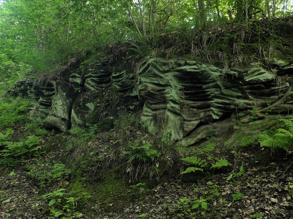
The mysterious Giant’s Grooves are hidden in a tiny ravine under a lush foliage. This place is unreal. Like an enchanted emerald chamber; radiating green and moisture. There is a brook at the bottom too. One of the sandstone slopes is covered in peculiar grooves and cup marks.
It is unknown how, when or why the cuts have been created. They were once thought to be made by neolithic folk sharpening their flint knives and axes. Modern research shows that they were probably caused by a rotating motion instead, perhaps using a wheel or pendulum. Today it is believed that those cuts are the remains of magical and religious rituals.
Historical maps of the village of Gantofta show that during the Middle Ages there was an increased interest in owning a narrow plot of land right there, but the reasons behind it remain unknown.
Grooves are common in northwestern Skåne, especially in Kullaberga, but they can also be found on Gotland where they appear mostly on single boulders. In folk belief some of them are called sword sharpening stones.
I’ve already visited Erkes dös this spring. The trip was brief though – the day was extremely windy and I haven’t explored the area much more beyond this point. But the information plate got me curious back then. It mentioned a local legend about an ancient path connecting Erkes dös with another grave, Stora Kungsdösen. Also since the Skånetrafiken app kept crashing that day, I’ve still had an unused ticket for this route. Yes, this trip was meant to happen again. I’ve decided to give this walk another go, and follow the trolls’ footsteps.
I took an early train down to Trelleborg. Fields were completely covered with fog, as thick as milk. I saw a roe (or maybe a mythical hare) standing on top of a burial mound. Unfortunately, since I was on a train, I haven’t had time to react and take a picture.
After a short bus ride and a walk through the fields I’ve reached Erkes dös, a majestic passage grave in Lilla Isie. By the entrance to the main chamber there are about 30 cup marks on one of the rocks. The site was excavated in 1915; amber beads and flint offerings have been found.
The local legend says that there used to be a path leading across the fields to the Stora Kungsdösen at Östra Torp. The path was made by trolls who went back and forth to visit each other. The map on Riksantikvarieämbetet (Swedish National Heritage Board) actually shows that an ancient paved road existed in the area. It was uncovered and investigated by Folke Hansen in the 1920s. The road briefly connected Erkes dös with another (now non- existent) passage grave in the south-west, and continued north-east towards Stora and Lilla Kungsdösen.
Stora Kungsdösen is a double passage grave; one of three of this kind in Skåne. Both chambers are exposed as they are missing their roof blocks. Not far from here, 150m to the east, there is another passage grave overgrown by trees. It is locally known as Lilla Kungsdösen.
Fog slowly started to clear up as I walked towards the sea. I’ve continued east on the coastal road and soon after I’ve reached a Bronze Age burial site with a cairn – Flinthög.
I’ve took a small fika in Smygehuk, the southernmost tip of Sweden and whole Scandinavian peninsula. Besides the lighthouse (Smygehuks Fyr) and a small marina there is also a humongous lime kiln to see and an unique viper population to avoid.
There is a Bronze Age burial mound hidden behind the kiln, Bålhög, which served as a navigation point. Before the lighthouse was build in 1883, fires (bål) were lit on the mound to guide ships.
An aged beech tree accompanies the mound; I was very pleased to rest under its branches.